Hiking the Timberline Trail
I don't think I've been on a true backpacking trip before. Back in high school, my friend Bart and I planned a multi-day trip to Carl Lake, but we ended up turning around after one night of camping at Cabot Lake because it was raining so much and we'd rather stay at his family's cabin instead. I also hiked up to Moraine Lake as a scout leader, on the way to South Sister, where we camped in preparation to summit Oregon's third tallest peak, but we left all of our gear at the lake on the second leg of our climb. That was back in 2001. I first learned of the Timberline Trail by reading a brief summary of it in, of all places, Portland Monthly. Sure, it was 35 miles farther than I had ever backpacked before, and it involved two more days and nights, and I would be going solo. But the summer of 2016 is all about change and new beginnings for me.
 Day 1: Timberline Lodge to Ramona Falls
I slept in Tuesday morning, as I was up late Monday night making my final preparations. The drive to Timberline Lodge was easy and uneventful, but once I arrived at the parking lot, the place was an absolute zoo. There must have been multiple summer camps going on, because kids dressed in ski attire dotted the landscape. I went in the lower lodge to confirm it was okay where I parked (you will be towed if you park in certain places overnight), strapped my pack to my back, and began looking for the trailhead, which proved harder than you might think, but which was a foreshadow of things to come. I eventually found a trailhead that said it was the Timberline, so I snapped a photo and began my journey. Rain was falling ever-so-lightly, but at least I was leaving behind the wind and the chill of the lodge area. But I still wasn't pleased with the worries I had lingering at the back of my mind about what I was about to embark upon. Low-hanging clouds and mist floated everywhere, which made visibility very poor for most of the day--forget about seeing Mt. Hood.
If you had told me that I wouldn't see anyone on the trail for the first two hours, I would have called you crazy. But that's what happened. I passed a pair of men, who also appeared to be backpacking the Timberline, just before our first major river crossing: The Zigzag River. And I'm pretty sure that was the last people I would see walking in the same direction for the remainder of the day. I was making great progress (the fastest of my trip, although I was utterly fresh and it was downhill) and didn't feel any strain from the weight of my pack, but I took it off, ate some lunch, and began learning how to scan a river for where best to cross. River conditions can change rapidly, so just because the trail puts you out at location X, doesn't make it the best place to cross. And just because you cross at point X doesn't mean that is where the trail picks up again. The Zigzag was easy: there were rocks to step on the entire width, so I did it without getting my feet wet, and finding the trail again was simple.

The rest of the day was pretty uneventful: I would see maybe one person or a group of two coming in the opposite direction every other hour, the streams to cross were regular but easy to walk over, and the clouds and mist continued to block any sort of view of the mountain. Near the end of the day's hike, I came to the Sandy River, which my printed guide proclaimed to be one of the more difficult crossings of the hike. The actual crossing was pretty simple: there were a couple of logs that spanned the river in one spot that once again kept my feet dry. What did prove difficult was finding this crossing and, once safely across to the other side, figuring out where the trail picked up, because it could be either upstream or downstream, sometimes 100 meters or more from where you crossed. I soon met my new best friend: cairns. I always thought cairns, little stacks of stones people made, were simply artistic in nature, but they proved to be life-saving landmarks that guided me out of many confusing situations over the next four days. I would learn by the end of the trip to look for the cairns to guide me quickly back to the trail. But since this was my first tough crossing, it took some time to learn this, but eventually I found the trail and made the last mile of the day to Ramona Falls. My FitBit says I was hiking for about four hours, with about 90 minutes of breaks, when I arrived just after 5:00 p.m.
 Several years ago we camped near Ramona Falls over the fourth of July (wow, it was only three years ago--it seems like forever and a day). Aaron, Edward, and I attempted to reach the falls, but we turned around before we actually made it. I think I recognized walking part of this trail, but the sad part was that we were probably only five minutes away from actually reaching the falls. There were a few people taking in the falls when I arrived, and a few that came after, but for the next 14 hours I was the lone guardian of Ramona Falls. I found a campsite on a small ridge just off the trail yet out-of-sight. It felt good to drop my pack and set up camp, although I was still feeling like a champion with no pain or soreness at all. My meals for the four days were pretty simple: I bought some freeze-dried meals for dinner, had instant oatmeal for breakfast, and instant hot chocolate to drink. I only needed to boil a few cups to prepare these meals, so it was quick way to get a hot meal down my eating hole. After dinner I returned to the falls to fill up my water bottles--I had two 32 oz Gatorade bottles that I was re-using. I literally became one with the falls by supping from its riches. I also spent many minutes simply contemplating the beauty and power of the nature before me, without any distractions.
Day 2: Ramona Falls to Elk Cove
 I didn't sleep well, but getting up around 6 or 7:00 a.m. was no problem. I enjoyed my simple breakfast of donuts, oatmeal, and hot chocolate, which was a great way to fuel my longer-than-expected day. I broke down my camp and was back on the trail just after 9:00 a.m. The hike started with a gradual uphill, which I will take almost any day over yesterday's mostly downhill trek. At one point on a high ridge, I must have run into a bush that whacked at one of my water bottles, which were holstered on either side of my pack, and sent it hurtling down the cliff's edge, gone forever. This would make things more difficult having only one bottle for water, but it wasn't the end of the world; frankly, I was more upset at my inadvertent littering of this paradise. I made sure to guard my other bottle very carefully for the rest of the trip.
 The sun also came out of hiding, and Mt. Hood was on beautiful display all day--pretty much for the rest of my trip. This made the going much warmer, so I eventually tore off all of my layers except my shirt. My pant legs are removable, so I took them off and stuffed them into my pockets when I realized I would need to actually wade through my first river crossing, the Muddy River. Crossing the river without the aid of any bridge (however crudely constructed) gave me a new boost of confidence: I can do new, challenging things. But then I couldn't find the trail. I scoured the riverbank, both up and downstream, but I couldn't find the trail or any cairns. Frustration started to slowly settle in, but it was early in the day so I wasn't worried about the time time I was losing. But this still led me to make my first stupid decision: I tried climbing a ridge to see if I could see the trail from higher ground. The ridge wasn't quite sheer, but it was very unstable, and remember: I'm carrying a ton of weight on my back that totally throws off your center of gravity. I was literally clinging to rocks with both hands and feet, and just as I was reach the top my foot holds gave way. But I was able to pull myself up with my arms to the safety of the top of the ridge. I scanned the immediate area, but saw nothing helpful. Now I was more than just worried. My printed guide spoke nothing of this being a difficult place to re-find the trail, but consulting with my map told me which direction I needed to head, so I moved that way, with nothing more than hope to guide my way. After bushwhacking for a bit and crossing another stream, I found the trail. I don't know how I had missed it before, but you wouldn't believe the relief I felt. After 15 minutes I checked my pocket and realized that one of my pant legs was missing. If I hadn't lost my way off the trail, it would have been easier to find, but after five minutes backtracking and not finding it, I said screw it and turned around again. It would be warmer from here on out, so I didn't think I would miss their warmth at all (I was correct).
 Having Mt. Hood visible at all times was a blessing and a curse: it was fabulous looking at her majesty, but it was so tempting to take a picture every other minute from the seemingly new angle I was seeing. I met a few more people--all of whom were nice and friendly, both male and female, old and young and everything in-between--and stopped at Bald Mountain to rest and eat my lunch while sitting on a flat rock looking out over Mt. Hood. Putting on my pack started becoming noticeable in the sense that it was getting harder, and I was less motivated to get going again. After several more hours of hiking I came upon a beautiful meadow with a motionless pond; and sitting along its banks was an older couple that I had met earlier and shared some good conversation. I stopped to chat for a bit again, but then I made my second dumb mistake of the day: somehow, after talking with them, I stumbled onto an alternate trail. I have no idea how, but I was off and didn't realize it, until I was again bushwhacking and fording streams that shouldn't have been there. Eventually I found the trail, but I wasn't sure which way I was to go. What I didn't know, was that this was not the Timberline Trail, and I picked to go the wrong direction. For probably two miles. Downhill. Ugh. Eventually I turned around and admitted to myself that I had made a mistake. It was a tough mistake to correct, because I now had to hike two miles uphill during the hottest part of the day and I was running low on water. Fortunately the adrenaline rush that kicked in got me back to the place I recognized as having reached before, which was also next to a stream that I was able to get some water to relieve the deepest thirst I have felt in a while.
 After hiking a hundred meters I came upon the intersection with the Timberline Trail. I refused to beat myself up--and I really had to fight the urge to go back and see where I had been misled off the trail--because it was getting late in the day, there were a couple more major river crossings, and I was still a couple of miles from the place I intended to camp. So I put myself back in high gear and made it to Elk Cove around 7:00 p.m. My Fitbit had died during my return to the Timberline Trail (I actually plugged it into my backup battery and carried them while hiking--I'm a little OCD about accounting for my entire trip), and I accidentally stopped it once, too, but the three segments said I ended up hiking about 15 miles for the day. Phew. So you can imagine my relief at walking into camp, which was once again desolate of human activity. Except my first step into the wooded camping area yielded a mosquito bite. And then another, and another, and so on until I left the next morning. I was too exhausted to care; or, rather, I was too exhausted to expend any more energy, so I set up my tent, cooked and ate, and "relaxed" as fast as I could before climbing into my tent--and subsequently killing the rogue mosquitoes that had infiltrated my inner sanctuary. I read for a bit before passing into the unconscious. Despite expending what felt like every last bit of energy I possessed, I failed to sleep well.
Day 3: Elk Cove to Gnarl Ridge Shelter
 Despite not sleeping soundly, I was able to awake feeling mostly rested and not too sore. I cooked breakfast, tore down my camp, refilled my water supply, swatted at thousands of mosquitoes, and headed back out on the trail. Today was supposed to be the most challenging day, with the most elevation gains; the most dangerous river crossing of a part of the trail that is officially closed; and trails that were littered with fallen logs, tons of rocks, and snowbanks galore. I think Day 3 lived up to its billing, even when compared to yesterday's bonus miles and elevation thrown in.
It didn't take long to leave behind the pleasantness of Elk Cove: this section of the trail is in a burn area, and there were dead trees strewn everywhere on the trail. Several times I had to leave the trail to get around these obstacles. Fortunately, it was early in the morning so I had the extra energy and agility to move about without any issues. As I was walking through this area, I heard a notification on my iPad, which I had brought along in case of an emergency, but which I had failed to get a data signal--until now. It was my son Edward sending me a picture of something cool he had found, so I had a brief conversation with him, shared a picture of where I was at, and said goodbye. This would prove to be the only time I would communicate with the outside world on this trek.
 After about four miles of hiking in utter solitude, I came upon a viewpoint overlooking the Eliot Creek washout, the section of the trail that is officially closed because of what a giant storm did to the area back in 2006. It was a bit intimidating to look down upon. I saw some motion from the corner of my eye, and I turned around to see if something had fallen from my pack, when I saw a tall, bearded man standing right behind me. I gave off a little yelp, which probably startled the man even more than he had me. We chatted ever so briefly before I let him go around me. He seemed in a hurry, and his pace was obviously faster than mine, plus I didn't mind following him down and around the most dangerous part of the hike. I still kept my distance, so as to not endanger one another as we made our way into the bottom of Eliot Creek. It wasn't too bad, but it was certainly the hardest part of the trail that you are supposed to do. After making the difficult crossing of one of the swifter rivers, I stopped along the river to eat lunch. My new friend had already high-tailed it out of there and was on his merry way. After 30 minutes of relaxing and reveling in my accomplishment--everything from here on out should be easy, right?--I saw a group of four making their way down the east bank of the slope that I was about to climb. I suited up while they were making their descent and talked to them for a bit about how to make it up and back to the official Timberline Trail again. One man was especially helpful and gave the tip of the trip: he told me to ignore the trail that heads out along the ledge of the ridge and to just keep going straight. This was helpful because I had seen others--including my friend from a few minutes ago--walking along the ridge, so I figured that was the right way to go. Wrong. I love the instant camaraderie of my fellow hikers.
 Once I was over the ridge and back on the official trail, I was feeling great and looking forward to finishing the last five miles of the day. But the farther I moved on from Eliot Creek, the harder the trail got: it began to rise rapidly and it was full of loose rocks and sand. But that wasn't the worst part: there began to be huge patches of snow--hundreds of meters in width--that covered the trail. And these snow patches were everywhere on this side of the mountain, which doesn't see the sun as much. The snow actually felt good to walk on, as it subtly cooled my warming body. It was a bit nerve-racking, though, because even though the snow was mostly solid, one false step could have sent me sliding down the mountain. Each step I took was with purpose and trying to follow the impressions that those before me had left. I learned that I couldn't look down the mountain, focused on one step at a time, and talked to myself to make sure I stayed properly motivated.
 After crossing these snowbanks seemingly forever, the trail was gone. Just plain missing. No cairns. No more tracks in the nearby snowbanks that could have been hiding the trail. Nothing. Ugh. How did this keep happening to me--and with only about two more miles until my next camp? I decided to head back over the last four snowbanks to the last cairn that I recall seeing, as there was another trail that looked like it could have been the right way to travel. After backtracking to the cairn, I headed out on this new trail. It led uphill for a bit before running into the snowbank that the picture at the left shows. There were tracks that went up to, from my vantage point, what could have been a trail on solid ground, so I gave it a go. The path was straight uphill, and I thought that this better be the right way because there was no way I going to be able to head back down. When I reached the end of the tracks in the snow, I saw that they didn't reach a trail on solid ground, but rather they led to a set of tracks where somebody had then proceeded to ski down the slope I had just climbed. I kept calm, as I was able to do during every stressful situation I encountered on the trip, turned around, and began slowly making my way back down the path. I made it safely down, but I was still not sure where to go. So I went back the way I had originally traveled, hoping that my new sense of urgency would help me find the trail. When I reached the point of confusion again, there was still no new revelation for where I was to go. I was still feeling pretty frustrated, but I began walking around the little plateau to see if I could find anything. I encountered a gorgeous campsite, which had a nearby stream I could drink from, that I decided would be where I would stop for the day if I couldn't find the trail soon--instant relief. I took off my pack, filled up my water rations, then began exploring the area in hopes of finding the trail. My saunters lasted for 15-30 minutes when I saw in the distance what I thought was a rock shelter--perhaps Gnarl Ridge, where I was supposed to camp that night. Knowing where that target was, I was able to backtrack along the landscape to find the logical place for where the trail should be. It worked. The thing is, there was no logical way the actual trail could have worked like it did, since it was so disjointed. There were no tracks or trail to connect with where I was to where I needed to go, so I had to bushwhack and slide down some loose gravel for a time before I found a snowbank much lower down the mountain and which appeared to be the trail. And sure enough, I was right. You would not believe the sweetness of the relief I felt upon finding the trail again. Of course, during my time of distress, not a single person happened to walk by, although this was probably the most remote part of the trail. I soon encountered a woman hiking with her dog, and she provided additional comfort and confirmation that I was headed in the right direction again.
 I was on the trail for maybe 45 minutes until I reached the Gnarl Ridge Shelter, a former shelter that had seen better times, but a marker for one of the most amazing campsites I have ever stayed at, which was on the other side of the trail. And wouldn't you know it: the site was once again all mine for the night. There were no nearby creeks or rivers, but there was snow by the shelter that I was able to dig down into and boil to use for my dinner that night. You wouldn't believe how good freeze-dried food can taste when your physical and psychological limits are pushed--those were the best damn biscuits and gravy I've ever tasted. The sun was setting behind the mountain during my meal, so I took breaks to take pictures and admire the spectacular scene unfolding before my eyes. My body was feeling pretty destroyed at this point: my shoulders, hips, and calves were all searing hot with pain, and every time I rose to stand or tried to sit down, my buttocks screamed out in agony. Sleep seemed to fix all that ailed me in the past two nights, but I was starting to doubt that this pattern could continue for much longer.
Day 4: Gnarl Ridge Shelter to Timberline Lodge
 I realized that I was in position to capture an amazing sunrise over Mt. Hood, so my usual restlessness made it very feasible to leave my tent at 5:30 a.m.--although it was a bit chillier on this side of the mountain, and oh how sore my legs felt when moving for the first time. After capturing what I felt was peak sunrise, and read for a bit in the warmth of my tent, and then began preparing to leave camp. I went to scoop some more snow from the other side of the trail, but it had frozen solid in the night. I didn't want to use the last of my water reserves for cooking, as I didn't know where the next source of water would be, but I was getting sick of oatmeal anyway, so I didn't mind foregoing a hot breakfast--plus, it allowed for me to get hiking on the trail that much earlier. I was definitely excited to finish the route and return to the comforts of home and life in the city.
 The trail began going downhill almost immediately. There were a few snowbanks and trees blocking the path, but nowhere near the severity like yesterday. As I was crossing one of the more difficult rivers, Newton Creek, I realized that I was getting pretty good at spotting safe places to ford the rivers, spotting and following the cairns, and then reconnecting with the Timberline Trail again. I also began staying a little longer at each river, not just to fill up my water supply, not waiting for people to converge and initiate conversations with, but to embrace the moments of solitude and serenity that I would soon be leaving behind. I was soon hiking through the Mt. Hood Meadows area and, despite the gradual change from back-country to front-country (i.e., ski lifts and other signs of human existence), I still didn't see any other people, and the journey was still amazingly peaceful.
 While hiking through the meadows area, I figured I'd continue with my tradition of going off-trail. This part of the trail was filled with grassy meadows and wildflowers, small streams, and killer waterfalls, one of which the trail would seemingly take me by. I was a bit overwhelmed by its beauty
and wasn't paying attention when, of course, I found myself off trail again. I was following a semi-trodden path that was following the river up the canyon to its source, so I knew that couldn't be the way to go. But even after turning around and making it back to the last known point of the trail, I still couldn't figure out where I was supposed to cross. Looking at the picture at the left, the crossing was near the top of the waterfall; I guess I never thought of that as a logical place for the trail to cross, but I felt pretty dumb once I realized how easy it was to see. But don't worry: I would have one more moment of silliness before I would be relaxing in the comforts of my car.
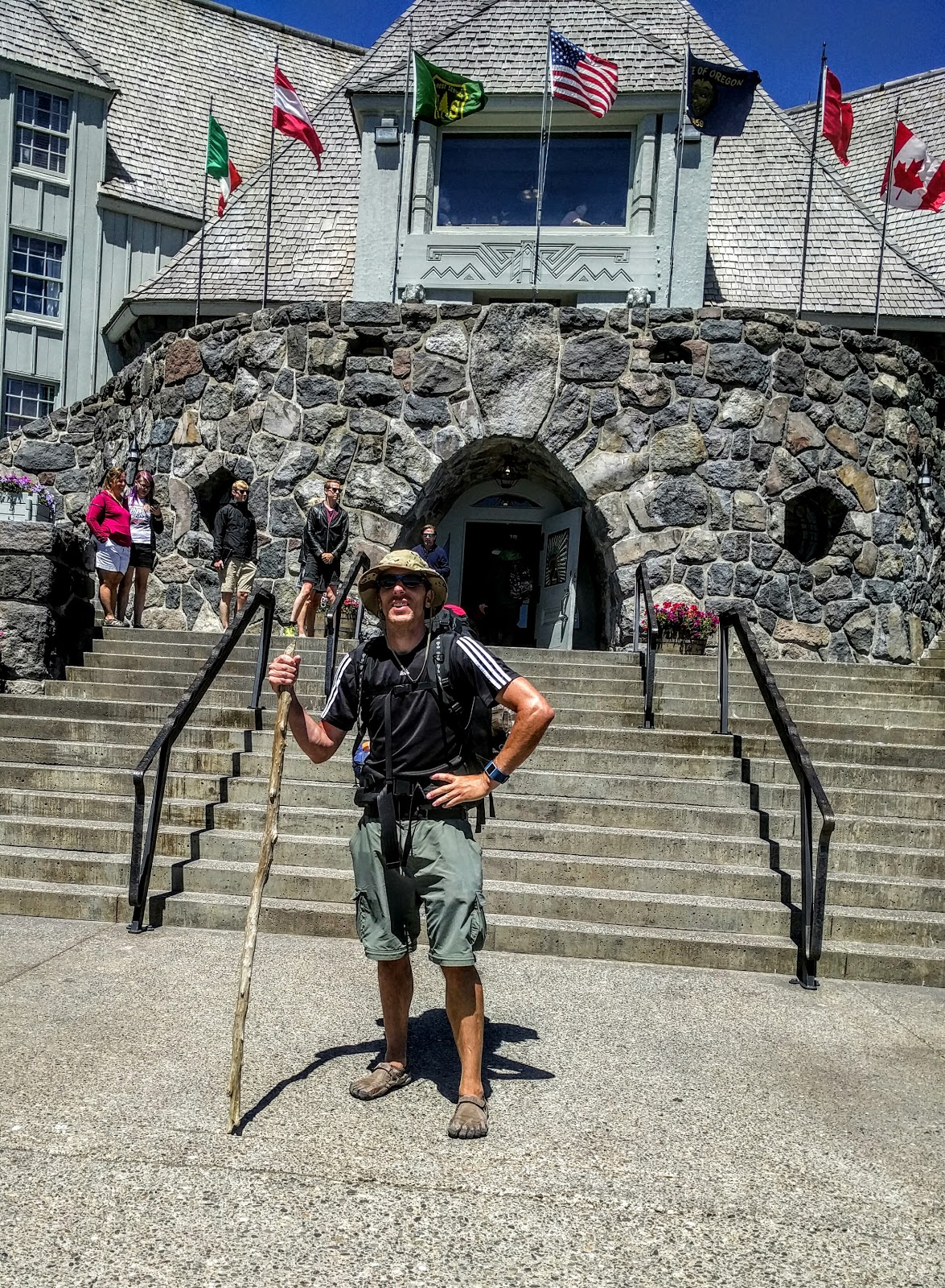
 The rest of the hike to Timberline Lodge was pretty plain-Jane (although the crossing at White River was one last moment of excitement): tame terrain, sightings of day hikers out from the Lodge, and even some not-as-crude log bridges spanning some of the smaller creeks. But the last two miles were uphill and, despite my printed guide saying at least the ascent was gradual, my body begs to differ. It was tough after already hiking 40+ miles, and I probably was audibly giving motivational speeches to myself to keep me going--especially after being able to see the Lodge and my car but knowing I still had 20-30 minutes left to go. But I promised myself I would buy the largest Pepsi I could find at the Lodge and drink my sorrows away. My final mistake was at the very end, a mere five minutes from the parking lot: the trail appeared to split into two paths, one going to what I thought was a dead-end that overlooked yet another canyon I would eventually have to cross, and another one that went straight up the mountain. Of course I chose the wrong path up the mountain, but after five or ten minutes of climbing, I turned around, made it back to the divergence, and realized the error of my way. Again. Ten minutes later I was taking my celebration picture in front of Timberline Lodge, and feeling an overwhelming sense of pride and accomplishment. I was a little fearful of entering the Lodge to look for a vending machine--I was covered in nature's spoils and smelled, probably, very natural--but I deserved that Wild Cherry Pepsi, so I bought one, walked to my car and, just before I could take off my pack, was approached by a woman wanting me to take a family photo with Hood in the background. She waited patiently while I unloaded my pack, and after I explained what I had just done, she was very interested and excited for me. I took a picture for her, and she took one in kind for me, too. Finished. It was sunny at the Lodge, but it was also a bit chilly with the wind blowing and my sweat evaporating rapidly, so I sat in my car to warm up, drank my Pepsi to feel better (and to wake me up), and relaxed for a bit to make sure I was ready to drive home. And that's the story of my first real backpacking trip.
Overall Reflections and Worthless Stats
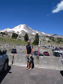

I slept in Tuesday morning, as I was up late Monday night making my final preparations. The drive to Timberline Lodge was easy and uneventful, but once I arrived at the parking lot, the place was an absolute zoo. There must have been multiple summer camps going on, because kids dressed in ski attire dotted the landscape. I went in the lower lodge to confirm it was okay where I parked (you will be towed if you park in certain places overnight), strapped my pack to my back, and began looking for the trailhead, which proved harder than you might think, but which was a foreshadow of things to come. I eventually found a trailhead that said it was the Timberline, so I snapped a photo and began my journey. Rain was falling ever-so-lightly, but at least I was leaving behind the wind and the chill of the lodge area. But I still wasn't pleased with the worries I had lingering at the back of my mind about what I was about to embark upon. Low-hanging clouds and mist floated everywhere, which made visibility very poor for most of the day--forget about seeing Mt. Hood.
If you had told me that I wouldn't see anyone on the trail for the first two hours, I would have called you crazy. But that's what happened. I passed a pair of men, who also appeared to be backpacking the Timberline, just before our first major river crossing: The Zigzag River. And I'm pretty sure that was the last people I would see walking in the same direction for the remainder of the day. I was making great progress (the fastest of my trip, although I was utterly fresh and it was downhill) and didn't feel any strain from the weight of my pack, but I took it off, ate some lunch, and began learning how to scan a river for where best to cross. River conditions can change rapidly, so just because the trail puts you out at location X, doesn't make it the best place to cross. And just because you cross at point X doesn't mean that is where the trail picks up again. The Zigzag was easy: there were rocks to step on the entire width, so I did it without getting my feet wet, and finding the trail again was simple.

The rest of the day was pretty uneventful: I would see maybe one person or a group of two coming in the opposite direction every other hour, the streams to cross were regular but easy to walk over, and the clouds and mist continued to block any sort of view of the mountain. Near the end of the day's hike, I came to the Sandy River, which my printed guide proclaimed to be one of the more difficult crossings of the hike. The actual crossing was pretty simple: there were a couple of logs that spanned the river in one spot that once again kept my feet dry. What did prove difficult was finding this crossing and, once safely across to the other side, figuring out where the trail picked up, because it could be either upstream or downstream, sometimes 100 meters or more from where you crossed. I soon met my new best friend: cairns. I always thought cairns, little stacks of stones people made, were simply artistic in nature, but they proved to be life-saving landmarks that guided me out of many confusing situations over the next four days. I would learn by the end of the trip to look for the cairns to guide me quickly back to the trail. But since this was my first tough crossing, it took some time to learn this, but eventually I found the trail and made the last mile of the day to Ramona Falls. My FitBit says I was hiking for about four hours, with about 90 minutes of breaks, when I arrived just after 5:00 p.m.

Day 2: Ramona Falls to Elk Cove


Day 3: Elk Cove to Gnarl Ridge Shelter

It didn't take long to leave behind the pleasantness of Elk Cove: this section of the trail is in a burn area, and there were dead trees strewn everywhere on the trail. Several times I had to leave the trail to get around these obstacles. Fortunately, it was early in the morning so I had the extra energy and agility to move about without any issues. As I was walking through this area, I heard a notification on my iPad, which I had brought along in case of an emergency, but which I had failed to get a data signal--until now. It was my son Edward sending me a picture of something cool he had found, so I had a brief conversation with him, shared a picture of where I was at, and said goodbye. This would prove to be the only time I would communicate with the outside world on this trek.


and wasn't paying attention when, of course, I found myself off trail again. I was following a semi-trodden path that was following the river up the canyon to its source, so I knew that couldn't be the way to go. But even after turning around and making it back to the last known point of the trail, I still couldn't figure out where I was supposed to cross. Looking at the picture at the left, the crossing was near the top of the waterfall; I guess I never thought of that as a logical place for the trail to cross, but I felt pretty dumb once I realized how easy it was to see. But don't worry: I would have one more moment of silliness before I would be relaxing in the comforts of my car.
Overall Reflections and Worthless Stats

- I climbed around 8600 feet in elevation.
- The high point of my trek was at 7300 feet, on Day 3 near where I camped. Remember, I live at sea level.
- The lowest point was 3200 feet, on Day 1 at the Sandy River.
- 48 miles hiked (according to my FitBit's GPS), averaging about 2.0-2.5 mph.
- The three campsites I stayed at were all logical and obvious places to stop for those hiking the Timberline Trail. Since nobody else stopped to camp with me, I think I may have been the only out there (at least on the same trajectory and who had left on Tuesday). That still boggles my mind.
- I'd like to do another trip like this in the future, but I think one a year of this magnitude would appease my need for adventure.
- Sure, hiking alone is more dangerous than when going with a buddy, but it was really something I needed. Not that there weren't times it would have been great to have someone to talk to and to help me stay on the stupid trail, but overall I'm glad I did it alone, and I wouldn't hesitate to do something like this solo again.
- The two most important tools I brought with me were a hiking stick and a very detailed map of the trail. The map cost $13, which might seem a little pricey (well, at least for a cheapskate like me), but it was worth 10 times its cost, and it provided so much help and confirmation that I was going the right way. The hiking stick, I think, was Edward's, and which I thought to put in the car at the last minute. It provided me with the proper balance on hundreds of occasions and prevented what would have been several falls, I'm sure.


Comments
Post a Comment